Geo How-tos
How-tosToolsTagsArchiveAbout
How-tos
Tools
Tags
Archive
About

Archive: R

Browse all archive tags →
  • spatialsample: R Package for Spatial Resampling
    June 21, 2022

    spatialsample: R Package for Spatial Resampling

    ↗ External
    spatialsamplerspatial-resampling
    The goal of spatialsample is to provide functions and classes for spatial resampling to use with rsample. Learn more here.
  • tidyterra: tidyverse and ggplot2 Methods for terra Spatial Objects
    June 21, 2022

    tidyterra: tidyverse and ggplot2 Methods for terra Spatial Objects

    ↗ External
    tidyterrarggplot2
    tidyterra is an R package that adds common methods from the tidyverse for SpatRaster and SpatVectors objects created with the terra package.
  • Cheat Sheet for sf R Package
    June 20, 2022

    Cheat Sheet for sf R Package

    ↗ External
    sfrcheat-sheets
    The sf R package provides a set of tools for working with geospatial vectors, i.e. points, lines, polygons, etc. Here is a cheat sheet guiding you in using sf.
  • tmap: R Package for Thematic Maps
    June 10, 2022

    tmap: R Package for Thematic Maps

    ↗ External
    tmaprcartographydata-visualization
    tmap is an open-source R package for drawing thematic maps. The API is based on A Layered Grammar of Graphics and resembles the syntax of ggplot2, a popular R package for drawing charts.
  • How to Map Population Density Using WorldPop and R
    June 9, 2022

    How to Map Population Density Using WorldPop and R

    ↗ External
    rpopulation-densitydata-visualizationtutorials
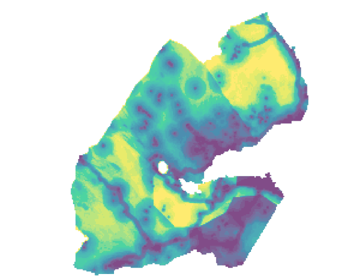
    This article will use WorldPop's population density dataset and walk through how to to map population density with R using data for Djibouti as an example.
  • Free Courses: Geography for Statistics Training
    June 8, 2022

    Free Courses: Geography for Statistics Training

    ↗ External
    gisstatisticsqgisrpythoncoursesgetting-started
    Check out these courses on geography, statistics, QGIS, and working with geospatial data in R/Python. These resources could be useful for anyone who integrates geography and statistics.
  • Cheat Sheet for ggplot2 R Package
    June 5, 2022

    Cheat Sheet for ggplot2 R Package

    ↗ External
    ggplot2rdata-visualizationcheat-sheets
    ggplot2 is an R package dedicated to data visualization. Here is a cheat sheet guiding you in using ggplot2 for data visualization.
  • How to Plot RGB Satellite Imagery in True-Color With ggplot2 in R
    June 3, 2022

    How to Plot RGB Satellite Imagery in True-Color With ggplot2 in R

    ↗ External
    ggplot2rimagerydata-visualizationprintingtutorials
    The ggplot2 R package does not natively support plotting raster data. This article presents a custom method for plotting RGB satellite imagery with ggplot2.
  • Building Bridges: Arrow, Parquet, and Geospatial Computing
    June 2, 2022

    Building Bridges: Arrow, Parquet, and Geospatial Computing

    ↗ External
    geoarrowgeoparquetrpython
    Read here about the motivations for using Apache Arrow in geospatial and how it can make geospatial computing faster for everybody.
  • Cheat Sheet for mapsf R Package
    June 2, 2022

    Cheat Sheet for mapsf R Package

    ↗ External
    mapsfrcartographydata-visualizationcheat-sheets
    The mapsf R package helps to design various cartographic representations such as proportional symbols, choropleth or typology maps. Here is a cheat sheet guiding you in using mapsf.
Previous2 of 3Next
Previous123Next
Geo How-tos
•
© 2025