Geo How-tos
How-tosToolsTagsArchiveAbout
How-tos
Tools
Tags
Archive
About

Archive: R

Browse all archive tags →
  • Cheat Sheet for cartography R Package
    June 2, 2022

    Cheat Sheet for cartography R Package

    ↗ External
    r-cartographyrcartographycheat-sheets
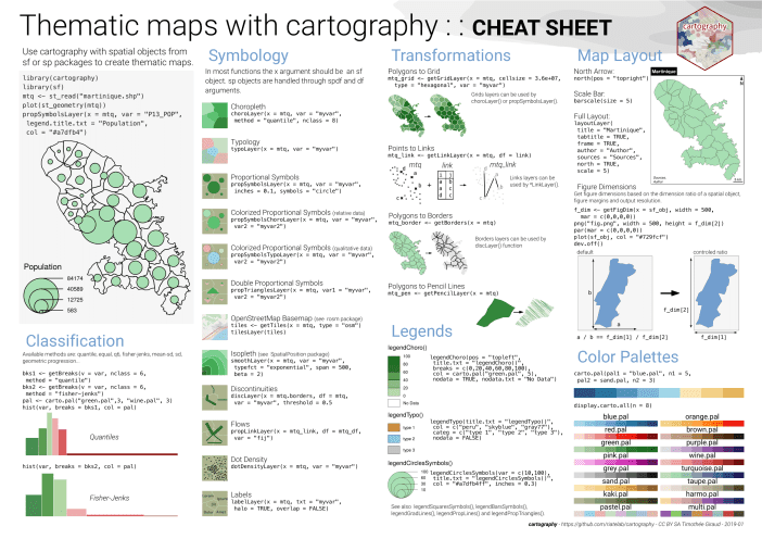
    The cartography R package helps to create thematic maps with the visual quality of those built with a classical mapping or GIS software. Here is a cheat sheet guiding you in using cartography.
  • Making Realistic 3D Topographic Maps in R
    May 29, 2022

    Making Realistic 3D Topographic Maps in R

    ↗ External
    rsfelevatrrayshadertopographyimagerydata-visualization
    This posts demonstates how to create realistic 3D topographic maps using R and satellite imagery as an overlay map.
  • How to Implement 'Zoom to Selected Features' With R Shiny
    May 10, 2022

    How to Implement 'Zoom to Selected Features' With R Shiny

    ↗ External
    rr-shinytutorials
    The 'Zoom to selected features' is a familiar functionality for ArcGIS and QGIS users. This post guides you through the steps required to build such a button in R Shiny using DT and leaflet packages.
  • Free Book: Geocomputation With R
    April 26, 2022

    Free Book: Geocomputation With R

    ↗ External
    rdata-processingdata-visualizationbooks
    If you are interested in data analysis, data visualization, and modeling of geographic data in R, you should check out this free book by Robin Lovelace et al.
  • Calculating NDVI From Landsat 8 Images With R and terra Package
    April 12, 2022

    Calculating NDVI From Landsat 8 Images With R and terra Package

    ↗ External
    ndvirterralandsatvideo-tutorials
    This is an applied example of NDVI calculation from the red and NIR bands from a Landsat 8 image.
  • Map Rivers With sf and ggplot2 in R
    April 10, 2022

    Map Rivers With sf and ggplot2 in R

    ↗ External
    rsfggplot2hydrologydata-visualization
    Check out this tutorial on mapping rivers in R using Global River Classification dataset.
  • CRAN Task View: Analysis of Spatial Data
    April 10, 2022

    CRAN Task View: Analysis of Spatial Data

    ↗ External
    rresources
    Visit the spatial CRAN Task View. It summarizes a lot of information about packages for working with geospatial data in R.
  • Treetop: An Application and R Package for Extracting Forest Information From LiDAR Data
    February 21, 2022

    Treetop: An Application and R Package for Extracting Forest Information From LiDAR Data

    ↗ External
    rr-shinylidarforestry
    Treetop simplifies extracting forest information for forest ecologists and conservationists who may use the tool to visualize tree positions and sizes, conduct complex analyses and download results.
  • Fast Geospatial Tasks Using R With data.table, sf and geos
    January 15, 2022

    Fast Geospatial Tasks Using R With data.table, sf and geos

    ↗ External
    rsfgeostutorials
    This blog post demonstrates some simple workflows for high-performance geospatial work in R, leaning on the data.table, sf and geos packages.
Previous3 of 3Next
Previous123Next
Geo How-tos
•
© 2025